
Located in the heart of Romagna, Castrocaro Terme and Terra del Sole and the surrounding area offer numerous possibilities for short, medium and long range excursions. You can decide not to stay too far from the town, choosing walking routes in nature, dotted with sites of historical, geological and naturalistic interest or landscapes that open up suddenly and leave you breathless. But you can also opt for one of the many possible bicycle routes, for more and less trained cyclists, cutting through the valleys and slopes of the area or attacking the hardest stretches with force to conquer the passes and peaks of the Apennines. Centaurs can try their hand at long distances and reach the Florentine territories, retracing the routes marked out by the ancient lords of the Medici Grand Duchy. Whichever route you decide to take, there will be plenty of opportunities to enjoy a luxuriant nature, to recognize traces of ancient history or to taste, during the well-deserved stops, the food and wine excellences that have made Romagna the home of “Good living”. From Castrocaro it is also possible to easily reach the many theme parks on the coast and in the hinterland: the Indiana Park in Bertinoro and the spectacular attractions of Mirabilandia, Atlantica, Fiabilandia, Italia in Miniatura, Oltremare and Acquafan.
- NATURE
- BIKE ITINERARIES
- CULTURAL
- FOOD&WINE
- EDUCATIONAL
- WALKING ITINERARIES

MOTORCYCLE ROUTE
The Municipality of Castrocaro Terme and Terra del Sole is the ideal starting point for many motorcycle lovers who wish to measure themselves against the twists and turns of the surrounding valleys.
One of the favorite destinations for centaurs is the Muraglione Pass, with its panoramic roads and numerous refreshment points where you can taste the typical dishes of the Tuscan-Romagna cuisine. Campigna is also one of the most popular destinations for excursions on two wheels, ideal for those looking – especially on summer days – for a bit of peace and refreshment.
Viale Marconi, 37
Castrocaro Terme e Terra del Sole (FC) 47011
IAT Castrocaro Terme
Tel: +39 0543 769631

NATIONAL PARK OF THE CASENTINESI FORESTS
The Foreste Casentinesi, Monte Falterona and Campigna National Park has an extraordinary biodiversity, both animal and plant. The woods, the prairies, mountains, streams and numerous animal species that populate the Park are harmoniously integrated with places of historical, cultural and religious interest.
The park covers 36400 hectares straddling Romagna and Tuscany; the Romagna side includes the valleys of Montone, Rabbi and Bidente and can be discovered (thanks to baout 600 km of trails) with pleasant excursions on foot, by mountain bike and on horseback or, in winter, with hiking skis and snowshoes.
In addition to the more demanding trekking routes, for expert hikers, there are also 9 “Sentieri Natura” (Nature Trails), short, easy routes along which there are observation points accompanied by information boards to illustrate the peculiarities of the environment and provide an initial tool for getting to know the area.
In addition, in Campigna and Badia Prataglia, two “Paths for all … the senses” have been set up, dedicated to anyone approaching hiking.
There are various Visitor Centres throughout the territory, important access and orientation structures for visitors, each dedicated to a specific theme inherent to the area in which it is located. In addition to the Visitor Centers, there are some useful Information Points.
Also located within the park are structures such as: the Valbonella Botanical Garden (in the municipality of S. Sofia), the Arboretum and the “Siemoni” Forest Museum in Badia Prataglia, the “G. Campadelli” Forest Museum in Campigna.
Throughout the area there are many rest areas equipped with tables and benches, some also with furnaces and drinking water fountains.
Palazzo Nefetti
via Nefetti, 3
Santa Sofia (FC) 47018
Parco Nazionale delle Foreste Casentinesi
tel. 0543 971375 – fax. 0543 973034
info@parcoforestecasentinesi.it
https://www.parcoforestecasentinesi.it/it

THE ACQUACHETA WATERFALLS - PORTICO AND SAN BENEDETTO - ON FOOT
The Acquacheta river is the most important tributary of the Montone and, before reaching San Benedetto in Alpe, it makes a leap of over 70 meters, forming the waterfall of the same name. Described by Dante in the 16th canto of the Inferno, it can only be reached by a couple of hours’ hike up the valley to reach, just above the waterfall, the charming Piana dei Romiti with the ruins of the ancient village.
It starts from San Benedetto in Alpe, a mountain village in Romagna at 485 m a.s.l.
Head towards the State road and, once you have crossed the bridge over the Fosso Acqua Cheta, take the path that runs along the stream. You’ll arrive in a beautiful alder wood, the landscape in some places looks like a painting, a work of art. The route is perfectly signposted, is part of the “Nature Trails” of the National Park and never strays far from the watercourse. Along the way there are 10 resting and observation points.
After passing the old building called Ca’ del Rospo, a steep climb begins that leads up to the ancient Romiti Mill, a resting place.
There is less than 1 km to the waterfall, but this is the most demanding stretch that, with a series of up-and-down steps, finally leads to the destination. The roaring sound of the water heralds the waterfall, which appears in its beauty and majesty, with a height of 70 m and a width of up to 30 m.
The spectacle of nature, in its shining beauty, is worth the effort; you can rest on the benches right where Dante also stopped to look at the waterfall.
More trained hikers can continue to the top of the waterfall, on the Romiti alluvial plateau.
Not far from the waterfall is the Lavane cascade, which forms a wonderful natural green water pool that invites you, in the summer, to bathe and find a cool refreshment. In a few minutes you can reach the plateau to observe the ruins of the Hermitage that belonged to the Abbey of San Benedetto in Alpe.
The destination of the excursion has been reached. The return follows the same route as the outward journey, the total time of the outing is 3 hours.
The path offers a brief escape from reality, offering fairytale views, far from the chaos of the city, in a wood that seems enchanted. The silence is only broken by the roar of the water or the rustle of the wind in the branches, and you can hear the birds singing and the woodpecker ticking on the wood.
Journey time: 3 h
Difficulty: easy
Lenght: 5 miles (8 km)
Elevation gain: 235 m
Way to travel: on foot
Tip: the best time for this hike is undoubtedly March-May; however, even on sunny days in early autumn you can enjoy the beauty of the waterfall.
Portico e San Benedetto
Ufficio IAT Castrocaro Terme
Tel: +39 0543 769631

THE RIDRACOLI DAM – BAGNO DI ROMAGNA
In the heart of the Foreste Casentinesi, Monte Falterona and Campigna National Park, surrounded by luxuriant vegetation that marks the passage of the seasons, tinged with evocative and intense colours, lies the Ridracoli Dam.
It is an artificial reservoir, built between the end of the 70s and the beginning of the 80s, its reservoir is able to contain 33 million litres of water (purified by the Capaccio potabilization center and distributed through the Romagna aqueduct to almost 50 Romagna municipalities).
Lush woods populated by hundreds of animal and plant species cover almost the entire territory to the point that it can be crossed in all its extension without ever leaving the luxuriant green mantle that surrounds it.
Located at 557 m above sea level, with a retaining wall 432 m long and 103.5 m high, the dam was built in perfect harmony with the surrounding environment, collecting the waters of the Bidente and Rio Celluzze rivers. Today the lake looks very similar to a fjord in Northern Europe: narrow and long it slides through the woods for about 5 km.
A visit to the Ridracoli Dam offers many opportunities for those who want to spend a day in peace and quiet, enjoying an evocative and lush landscape. Among the services offered there are trekking routes, outdoor picnics, excursions by electric boat, canoe trips, mountain-biking and e-biking, guided tours ofthe tunnels of the dam; the moment of overflowing, when the waterfall comes to life following the rain and the melting of the snow, is always spectacular.
The territory around the dam is crossed by numerous nature trails, one of the most popular is the one that leads to the Ca’ di Sopra refuge, a not very demanding route of about 5 km (round trip), that offers breathtaking views of the lake, the dam and much of the local fauna. In fact, during the excursions around the lake, it is easy to observe the animals that populate the upper Bidente valley: ungulates (wild boar, deer, roe deer, fallow deer), porcupines, both diurnal and nocturnal birds of prey (eagle, hawk, goshawk and eagle owl), as well as amphibians (newts, salamanders, the yellow-bellied toad). Also noteworthy is the presence of animals that only recently inhabit the area, attracted by the fish abundance in the basin, such as the grey heron and the cormorant.
In the vicinity of Ridracoli, thanks to the intervention of Romagna Acque, some farmhouses used by tourists have been completely renovated while “IDRO – Ecomuseo delle acque”, in the village of Ridracoli, is an interesting scientific museum, on four floors, that explores the secrets of water and forest, making the visit more interesting for adults and children.
Borgo di Ridracoli 47021 – Bagno di Romagna (FC)
IDRO Ecomuseo delle Acque di Ridracoli
Tel 0543 917912
Fax 0543 903733
ladigadiridracoli@atlantide.net
http://www.ridracoli.it/

RUPE DEI COZZI ITINERARY ON FOOT
Of extreme naturalistic interest, this route allows you to jump millions of years back in time, walking among fossil stones where the shells of ancient sea shells, the spungone, are clearly visible; the force of water and wind have eroded and shaped the landscape, creating fascinating caves and ravines.
The start is in front of the entrance to the Spa in Viale Marconi. From here you reach Piazza Mazzini and then walk along Via delle Sorgenti up to the bridge near the old brick furnace. Turn left and proceed along Via Rio Cozzi, skirting the Rio Piano stream (a particularly shaded area).
After 1,500 meters, turn left and proceed along the dirt road for a few hundred meters as far as the barrier: at this point, turn right and the country road that leads to the Rupe dei Cozzi begins.
After the Rupe dei Cozzi, proceed on a flat and grassy stretch and reach a crossroads: at this point we recommend a short detour to the right following the dirt road so that, after travelling uphill for 200 meters, you can admire the extraordinary landscape of the Bolga Lakes where the salsojodic waters flow and are collected and conveyed to the thermal establishments by means of an underground pipeline.
Returning to the crossroads, turn left, cross the ditch and follow the road, located in the middle of the vineyards, which leads to the Azienda Agricola Valle di Mezzo farm: once you reach the farmyard, proceed left along the dirt road leading to the Pergola farm and then continue downhill along the paved road to the town. The last stretch runs alongside the Rocca and the ancient walls of Castrocaro Terme.
Route: Castrocaro Terme – Rupe dei Cozzi – Valle di Mezzo – Pergola – Via Bagnolo – Castrocaro Terme
Starting point: entrance to the Baths
Route: ring
Elevation gain: 180 m
Length: 4 miles (6,8 km)
Main environment: valley bottom, valley, coast
Road type: asphalted and dirt
Viale Marconi, 37
Castrocaro Terme e Terra del Sole (FC) 47011
Ufficio IAT Castrocaro Terme
Tel: +39 0543 769631

RIVER PARK ITINERARY ON FOOT
This excursion is ideal for those looking for a bit of tranquillity without straying too far from the city center as it is quite short and easy; it leads to the gates of Terra del Sole through the River Park, a green and well-equipped area that winds along the Montone river.
The starting point is in Via Conti, before the bridge over the river on the left; proceed along the path that runs alongside the Parco delle Terme and the river and, after a few hundred meters, opens out onto a large meadow. Follow the main path to the municipal sports centre: here cross the Montone river over the characteristic humpback bridge and continue left for a few hundred meters until you reach the end of the River Park.
For the return, you can follow the same route or, if you want to shorten the journey, you can leave from the main entrance in Via Ravaglioli.
Route: excursion through the river park
Starting point: Via Conti (Spa entrance)
Route: round trip
Journey time: 1 hour
Length: 3 miles (4,5 km)
Main environment: Park
Road type: dirt path
Viale Marconi, 37
Castrocaro Terme e Terra del Sole (FC) 47011
Ufficio IAT Castrocaro Terme
Tel: +39 0543 769631

PANORAMIC CORTINA-BAGNOLO ITINERARY ON FOOT
A walk that allows you to appreciate the natural beauty of the area through particularly suggestive views. Starting in front of the Spa in Viale Marconi, proceed along Via Roma, Via Garibaldi, Via Maltoni, Via Biondo until you reach the little Caduti church. In front of the church, turn right into Via Baracca, which later becomes Via Savelli, until you reach Sorgara; continue to the right along Via Zanetta, where the gravel road begins to climb up to the Cortina farm, after which it winds along the ridge. At the end of the dirt road, turn right into Via Bagnolo where the path becomes paved and downhill; after a few hundred meters on the left side are the “Maestà Mater Consolationis” and the church of Bagnolo. The road that leads to Castrocaro follows the course of the limestone ridge above. It is a suggestive view that highlights the great contrast between the limestone masses, devoid of vegetation, and the surrounding area mainly sandy-clayey. The area is indeed dotted with vineyards, olive trees and other crops.
The last section of the route runs alongside the Rocca and the ancient walls of Castrocaro.
Route: Castrocaro Terme – Sorgara – Cortina – Bagnolo – Castrocaro Terme
Starting point: Spa Entrance
Route: ring
Journey time: 3 hours on foot
Elevation gain: 230 m
Length: 6 miles (9,3 km)
Main environment: coast and ridge
Road type: asphalted and gravel
Viale Marconi, 37
Castrocaro Terme e Terra del Sole (FC) 47011
Ufficio IAT Castrocaro Terme
Tel: +39 0543 769631

ITINERARY OF THE PIANELLO ON FOOT
The itinerary leads to the suggestive Castle of Monte Poggiolo, an ancient bastion erected in a strategic position and therefore disputed over the centuries by the various lords of Forlì, Castrocaro and Faenza.
Today it is only possible to admire what remains of the outer structure of this fortress, which has been weathered by time, while the surrounding landscape retains its beauty intact. The recommended departure point is from Piazza d’Armi in Terra del Sole: head towards Forlì and, just outside the walls of the Medici citadel, turn left into Via Cesare Battisti. Follow this road until you meet Via Pianello, on the left, which climbs up the hill. Following the road you cross poultry farms, after which the road becomes gravel as far as the junction for the Pennita.
Here we follow the dirt road to the left, which continues to climb until we reach the Converselle – Monte Poggiolo ridge road, then turn right towards Monte Poggiolo, where we meet the castle. From here, descend along the tarmac road towards the valley floor. Before reaching the plain, on the right, we come across an old rural house, not far from the road we are following, which is called Palazzo del Diavolo (Devil’s Palace).
At the crossroads, at the end of the descent, turn right onto Via Mercatina and then follow Via Cesare Battisti until you reach the main road near Terra del Sole. The last section of the route runs alongside the Rocca and the ancient walls of Castrocaro.
Route: Terra del Sole – Pianello – Monte Poggiolo – Ciola – Mercatina – Terra del Sole.
Starting point: Piazza d’Armi, Terra del Sole
Route: ring
Journey time: 2 hours
Elevation gain: 150 m
Length: 3,5 miles (5,5 km)
Main environment: coast
Road type: asphalted and dirt
Viale Marconi, 37
Castrocaro Terme e Terra del Sole (FC) 47011
Ufficio IAT Castrocaro Terme
Tel: +39 0543 769631
info@castrocarotermeterradelsole.travel

CONTRABBANDIERE ITINERARY ON FOOT
An evocative route along a ridge that skirts a landscape to the south-west, characterized by calanchifera formations, dotted with brooms and onion. In springtime, the vegetation creates a chromatic explosion that makes every step unforgettable. Roe deer, hares and pheasants, which can be easily spotted, populate the environment. The starting point is in front of the entrance to the Spa in Viale Marconi; from here you reach Piazza Mazzini and then continue along Via delle Sorgenti up to the small bridge near the old furnace. Immediately after the bridge, turn left into Via Rio Cozzi and, after 50 meters, leave the main asphalt road and take the gravel road on the right that begins to climb the hill (the diversions is indicated by the sign on the retaining wall) . Continuing along the gravel road, past the house of the Mezza Collina farm, we climb between characteristic hawthorn hedges and, as the road becomes a dirt road, we reach the top of the ridge and take the road that connects Converselle to Monte Poggiolo. At the crossroads, turn left towards Converselle. From the church of Converselle, retrace your steps for about a hundred meters and then follow, to the right, the paved road that descends to the valley floor. Continue alongside the main asphalted road that runs along the Rio del Piano until you return to the small bridge near the old furnace; from here, take Via delle Sorgenti and return to the town.
Route: Castrocaro Terme – Monte Calvario – Mezza Collina – Croce – Verna – Converselle – Castrocaro Terme.
Starting point: Entrance to the Baths
Route: ring
Journey time: 3 hours
Elevation gain: 150 m
Length: 12 km
Main environment: valley, coast and ridge
Road type: asphalted and dirt
Viale Marconi, 37
Castrocaro Terme e Terra del Sole (FC) 47011
Ufficio IAT Castrocaro Terme
Tel: +39 0543 769631

CRINALI-CONVERSELLE-MONTE POGGIOLO ITINERARY ON FOOT
This itinerary allows you to admire various sites of historical interest along the way and, once you reach the Castle of Monte Poggiolo, to enjoy an absolutely unique and extraordinary panorama. From the entrance to the Spa in Viale Marconi you reach Piazza Mazzini, then follow Via delle Sorgenti to the small bridge at the Old Brick Furnace. At the crossroads, beyond the bridge, turn left into Via Rio Cozzi and continue along this paved valley floor road (which later becomes Via Converselle), which runs along the Rio del Piano to the Casacce junction, marked by a special sign. At the Casacce junction, continue on the asphalted road to the right, which climbs the coast of Converselle with a hairpin bends route, up to the top of the hill, where the church of Converselle stands, recognisable by the small bell gable. A large lawn around the building allows for a comfortable rest. From the church of Converselle, retrace your steps for about 100 meters and then take the gravel road that leads to Monte Poggiolo following the directions on the route.
Continue on the road from the ridge with ups and downs between cultivated fields, orchards and vineyards, with wide views that open into the Forlì plain, until you reach the Castle of Monte Poggiolo. Admiring the view from this privileged spot, we descend along the tarmac road towards the valley floor. Before reaching the plain, on the right, not far from the road, there is an old rural house called Palazzo del Diavolo (where Garibaldi, pursued by the Austrians after the fall of the Roman Republic, found refuge). At the fork, at the end of the descent, turn right into Via Mercatina and then follow Via Cesare Battisti until you reach the main road near the walls of Terra del Sole. After crossing the Medici town, go along Viale Marconi to return to the entrance to the spa.
Route: Castrocaro Terme – Converselle – Golfara – Verna – Monte Poggiolo – Ciola – Mercatina – Terra del Sole – Castrocaro Terme.
Starting point: Spa Entrance
Route: ring
Elevation gain: 250 m
Length: 10 miles (15 km)
Main environment: Ridge
Road type: asphalted and dirt
Viale Marconi, 37
Castrocaro Terme e Terra del Sole (FC) 47011
Ufficio IAT Castrocaro Terme
Tel: +39 0543 769631

FROM CASTROCARO TERME TO SADURANO with the "DON DARIO PATH"
A route that allows you to discover the wonders of the landscape and forgotten places: an itinerary dedicated to those who love walks in nature and also approach these places spiritually.
From the entrance to the spa, walk along Via Roma and then turn left onto Via Conti. At the crossroads with the roundabout, turn right into Via Frassineti and then immediately turn right again into Via Neri; after 150 metres turn right again and cross the bridge over the ring road. After the bridge, keep to the left and take the path that after 700 metres ends in via di Sadurano. From here, after a short stop to admire the landscape, continue to the right along the road along the ridge and, after 1000 metres, you will reach the village of Sadurano, where Don Dario Ciani created a welcome and recovery community in 1975, active until 2015, the year of his death. Continue for 1,500 metres until you reach Monte della Birra (Mount of Beer), so called because of the Diamantina “Witch” who was confined there in 1603. From there, the path, with mountains and hills as far as the eye can see, begins to descend and, after passing Casa Collina and skirting cultivated fields, enters the woods that will take us to the ford on the Montone river. After crossing the river, we continue keeping to the right at the entrance to the provincial road and after 300 metres we cross the national road and proceed along Via Virano. The path then turns left to reach the Parco della Sorgara, no longer in use, a cool place where people once drank healthy waters and danced to the sound of local orchestras. Continue along Via Savelli to return to Castrocaro Terme.
Route: Via Roma – Via Conti – Via Sadurano – Monte della Birra – Montecchio – Sorgara – Castrocaro
Starting point: Spa Entrance
Route: round trip
Journey time: 3 hours
Elevation gain: 200 m
Length: 6 miles (10 km)
Main environment: coast and ridge
Road type: dirt and asphalted road
Viale Marconi, 37
Castrocaro Terme e Terra del Sole (FC) 47011
Ufficio IAT Castrocaro Terme
Tel: +39 0543 769631

Viale Marconi, 37
Castrocaro Terme e Terra del Sole (FC) 47011
Ufficio IAT Castrocaro Terme
Tel: +39 0543 769631

ANTONIAN ITINERARY ON FOOT
A route in the heart of nature that is also a spiritual experience, a pilgrimage in the footsteps of St Anthony’s last walk and which leads to the Hermitage of Montepaolo, where the saint from Padua retired in penance for nine months.
The starting point is in front of the entrance to the spa; from here you reach Piazza Mazzini, continue along Via della Fratta and begin the 4.5 km climb to Monte Cerreto (316 m above sea level).
After 1.4 km, just past the Petrosa farm, 50 metres from the main road, you come to the “Maestà di S. Antonio” cell on the right; continue along the municipal road, skirting Mount Sina until you reach the “Maestà Mater Consolationis” of Bagnolo. Continue for about 1 km to Monte Cerreto, where the dirt road begins. After another 500 metres, on the right-hand side, it is possible to admire the Grotta delle Fate (Cave of the Fairies), Mount Castellaccio and Mount Sassone (or of the owls).
The route now winds its way along the ridge, climbing until it reaches the Hermitage of Montepaolo.
After a break, you can proceed on the return route, following the outward journey backwards.
Route: Castrocaro Terme – Via Bagnolo – Monte Cerreto – Spiandarolo – Sant’Ellero – Montepaolo and back
Starting point: Spa Entrance
Route: round trip
Journey time: 5/6 hours on foot
Elevation gain: 440 m
Length: 11 miles (17 km)
Main environment: coast and ridge
Road type: asphalted and dirt road
Viale Marconi, 37
Castrocaro Terme e Terra del Sole (FC) 47011
Ufficio IAT Castrocaro Terme
Tel: +39 0543 769631

FROM CASTROCARO TERME TO MONTE POGGIOLO BY MOUNTAIN BIKE
A 27 km route where the forest frames narrow hairpin bends in an exciting up and down.
From the Castrocaro Terme plain, in less than 10 km of unpaved climb overlooking the valleys below, you reach Monte Paolo, where the Church of S. Antonio stands. Of unparalleled charm is the wooded environment around the Samoggia torrent, which is travelled downhill before tackling the toughest 900 metres that lead up, via narrow, gravel hairpin bends, to the old Converselle Church. From here, along an up and down ridge, we first reach the castle of Monte Poggiolo, then Terra del Sole.
Critical points: from the old thermal baths of Sorgara, follow Via Zanetta to the top, turning left to go along the whole ridge towards Montepaolo. Before the final climb you have to overcome a short steep stretch, near some houses.
Alternative paths: from Montepaolo, instead of turning right for the Samoggia stream, you can continue straight towards Dovadola to return to Castrocaro along the state road 67; or, turning right immediately after the Church of Converselle, you can take a paved road that descends between Terra del Sole and Castrocaro.
Route: Castrocaro Terme – Sorgara – Monte Paolo – Converselle – Monte Poggiolo – Terra del Sole – Castrocaro Terme – Rocca San Casciano – Castrocaro Terme
By mountain-bike
Difficulty: medium
Length: 17 miles (27 km)
Journey time: almost 2 hours
Viale Marconi, 37
Castrocaro Terme e Terra del Sole (FC) 47011
Ufficio IAT Castrocaro Terme
Tel: +39 0543 769631

FROM CASTROCARO TERME TO THE RIDRACOLI DAM AND SANTA SOFIA BY BIKE
A challenging route of about 120 km, in a constant alternation of climbs and gentle slopes, leads to a huge course of water surrounded by lush vegetation: the suggestive spectacle of the Ridracoli Dam will worth any effort.
From Castrocaro Terme follow the directions for Dovadola and Rocca San Casciano. In Rocca San Casciano, before the bridge, turn left towards San Zeno and Galeata; after a few hundred meters, face a climb of just over 5 km that leads to the top of Colle delle Centoforche (551 m a.s.l.). Get off to take the SS 9 ter; at the intersection, turn left, after 700 m you will reach San Zeno: at the crossroads, turn right towards Galeata and after 2.8 km of climbing you will reach the top of Monte delle Forche (444 m a.s.l.). From here, descend to the centre of Galeata, turn right for Santa Sofia and, after the bridge, follow the signs for Campigna and Florence. Continue along the state road for a few km, then turn left for Ridracoli and follow the tourist signs until you reach the dam. When you arrive at the gate that delimits the area of the dam (at 55.2 km), go uphill for 3 km. Once in Galeata, follow the outward route in reverse order. In Galeata follow the signs for Forlì. At 100 km you arrive in Meldola, cross the town and reach the hamlet of Para. Here, turn left towards San Martino in Strada in via Monda and at the crossroads turn right towards Forlì. After 2 km, at the traffic lights, turn left for Vecchiazzano and continue towards Castrocaro Terme.
Route: Castrocaro Terme – Rocca San Casciano – San Zeno – Galeata – Santa Sofia – Isola – Diga di Ridracoli – Santa Sofia – Civitella – Meldola – Para – San Martino in Strada – Castrocaro Terme
Viale Marconi, 37
Castrocaro Terme e Terra del Sole (FC) 47011
Ufficio IAT Castrocaro Terme
Tel: +39 0543 769631

FROM CASTROCARO TERME TO PASSO DEL MURAGLIONE THROUGH BRISIGHELLA AND MARRADI BY BIKE
A 170 km long challenge for trained athletes that tests physical endurance and tenacity. A gentle start, just long enough to warm up the muscles, soon gives way to a long sequence of steep climbs and tears. A demanding challenge… but what satisfaction to conquer the Muraglione!
From Castrocaro Terme follow the signs for Terra del Sole and Forlì; before Villa Rovere turn left for Villagrappa. At the crossroads, turn left towards Castiglione. Continue for 3.3 km. Turn left into Via Gesuita, then left again into Via Bianzarda S. Giacomo. After about 1 km, turn right into Via S. Mamante. At the next junction, turn left, then immediately right into Via S. Martino.
In Faenza (Ponte Rosso), at the junction with the Modiglianese road, turn left and then right towards Sarna and Brisighella. Once in Brisighella, proceed along the SS 32 following the signs for Marradi (21 km of ups and downs). In Marradi (FI), cross the town centre and continue along the state road to Colla di Casaglia (10 km of demanding uphill road). At the Colla di Casaglia pass (851 m above sea level), a long downhill stretch begins to reach Borgo San Lorenzo. Once in Borgo San Lorenzo, continue (on the flat) on state road 551 in the direction of Dicomano.
At Dicomano we take the SS 67 (in the direction of Forlì). The road climbs gradually: from just before S. Godendo to the Muraglione Pass the climb is demanding…but the finish line is now in sight. At the Muraglione Pass (907 m above sea level) the smooth descent towards the valley floor begins. Cross San Benedetto in Alpe, Bocconi, Portico di Romagna, Rocca S. Casciano and Dovadola to reach Castrocaro Terme again.
Route: Castrocaro Terme – Faenza – Brisighella – Marradi – Colla di Casaglia – Borgo San Lorenzo – Dicomano – S. Godendo – Passo del Muraglione – San Benedetto in Alpe -Rocca S. Casciano – Castrocaro Terme
Viale Marconi, 37
Castrocaro Terme e Terra del Sole (FC) 47011
Ufficio IAT Castrocaro Terme
Tel: +39 0543 769631

FROM CASTROCARO TERME TO SAN BENEDETTO IN ALPE THROUGH THE PASSO DELL'EREMO AND THE PASSO DELLA PESCHIERA BY BIKE
A 115 km route that is an exciting test of courage and physical endurance: to overcome the two mountain passes (at an altitude of almost 1000 m) along the route you really must… never give up!
From Castrocaro Terme follow the signs for Terra del Sole and Forlì. Before Villa Rovere, take Via del Braldo on the left towards Villagrappa and Faenza. At the crossroads, turn left towards Castiglione. Continue for 3.3 km, then turn left into Via Gesuita. Then turn left again into via Bianzarda S. Giacomo. After about 1 km, turn right into via San Mamante. At the next junction, turn left and then immediately right into via San Martino.
In Faenza (Ponte Rosso), at the junction with the Modiglianese road, turn left and then right towards Sarna and Brisighella. Once in Brisighella, proceed along the SS 32 towards Marradi (21 km of ups and downs). Once in Marradi, in the province of Florence, cross the town and follow the signs for San Benedetto in Alpe.
After 11 km of climbing, you reach the Passo dell’Eremo (921 m above sea level), and then face a descent of about 2.5 km. Resume the climb towards Passo della Peschiera (930 m above sea level), descending through sharp bends and steep slopes to San Benedetto in Alpe.
The road joins the SS 67: turn left and after a short stretch, the route is a gentle but continuous descent to Castrocaro Terme.
Route: Castrocaro Terme – Villagrappa – Faenza (Ponte Rosso) – Brisighella – Marradi – Passo dell’Eremo – Passo della Peschiera – San Benedetto in Alpe – Castrocaro Terme
Viale Marconi, 37
Castrocaro Terme e Terra del Sole (FC) 47011
Ufficio IAT Castrocaro Terme
Tel: +39 0543 769631

FROM CASTROCARO TERME TO SAN BENEDETTO - PASSO DEL MURAGLIONE AND RETURN BY BIKE
An 88 km route where the uphill is the master, through the numerous hairpin bends that lead to the top of the Muraglione Pass.
From Castrocaro Terme follow the signs for Dovadola, Rocca San Casciano and Florence; once in the town continue along the state road for Portico di Romagna, Bocconi and San Benedetto. The route is always a gradual uphill climb. Before the bridge on the right, in the square, there is a fountain: from San Benedetto in Alpe continue following the signs for Firenze.
The road from this point up to the Muraglione Pass presents some challenging stretches.
Before the beginning of the hairpin bends leading to the top of the pass, you enter the territory of the Tuscan region.
Once at the top, there is a chance to stop and have a meal before tackling the smooth descent to the valley floor to return to Castrocaro Terme.
Route: Castrocaro Terme – Dovadola – Rocca San Casciano – Portico di Romagna – San Benedetto – Passo del Muraglione e ritorno
Viale Marconi, 37
Castrocaro Terme e Terra del Sole (FC) 47011
Ufficio IAT Castrocaro Terme
Tel: +39 0543 769631

FROM CASTROCARO TERME TO PORTICO DI ROMAGNA TO PREMILCUORE, SAN ZENO AND ROCCA SAN CASCIANO BY BIKE
A 77 km route characterised by small roads and ups and downs through the Rabbi valley.
Follow the signs from Castrocaro Terme for Dovadola and Rocca San Casciano: go through the village and continue on the SS 67 (towards Florence). After several ups and downs you reach Portico di Romagna: after passing the village continue for about 2.5 km, then turn left (signposted for Premilcuore).
The road (Valbura) climbs for 7 km: a hard, final climb leads to the top of the Manzo Pass (840 m above sea level).
The descent to Premilcuore begins. Caution is advised: the road is narrow and winding and the road surface is not in perfect condition.
At the crossroads with the SS 9 ter, turn left towards Forlì. Continue for 10.5 km and, before reaching San Zeno, turn left for Rocca San Casciano. Climb for about 5 km to the top of Colle delle Centoforche (551 m above sea level). After a smooth descent with a few bends, you reach Rocca San Casciano.
From here, following the signs for Forlì, we return to Castrocaro Terme.
Route: Castrocaro Terme – Rocca San Casciano – Portico di Romagna – Bivio di Premilcuore – Premilcuore – San Zeno – Rocca San Casciano – Castrocaro Terme
Viale Marconi, 37
Castrocaro Terme e Terra del Sole (FC) 47011
Ufficio IAT Castrocaro Terme
Tel: +39 0543 769631

FROM CASTROCARO TERME TO MODIGLIANA, MONTE PRATELLO AND MONTE TREBBIO BY BIKE
A 77 km route that begins with a flat section that allows you to enjoy the view and gather your strength before tackling Monte Pratello and Monte Trebbio with hairpin bends, climbs and ramps.
From Castrocaro Terme follow the direction for Terra del Sole and Forlì. At Villa Rovere turn left towards Villagrappa and Faenza. At the crossroads turn left for Castiglione and Faenza. Continue for 3.3 km and turn left (Via Gesuita) and then left again (Via Bianzarda S. Giacomo). At the next junction turn right (Via S. Mamante). At km 13.670 turn left (Via Pozzo) and at the crossroads turn left again (Via Santa Lucia).
Continue for about 1.5 km and, after the small bridge over the Samoggia stream, turn right (Via Canovetta). Continue for about 3 km, then the road joins the SP Modiglianese: turn left for Modigliana. Near the Carabinieri barracks there is a fountain: proceed towards the centre and at the traffic lights turn left following the sign for Rocca San Casciano.
The climb that leads to Monte Pratello begins; after 6.4 km turn left into Via Morana to reach the top of Monte Trebbio; once at the top turn left towards Modigliana. After a few hundred metres turn right towards San Savino and Faenza (the road is characterised by continuous ups and downs for about 5 km until the Church of San Savino, then a fast and smooth descent begins). At the end of the descent continue along Via Samoggia and then Via Santa Lucia.
Continue along the same route until you reach Castrocaro Terme.
Route: Castrocaro Terme – Villagrappa – Santa Lucia – Modigliana – Monte Pratello – Monte Trebbio – San Savino – Santa Lucia – Villagrappa – Castrocaro Terme
Viale Marconi, 37
Castrocaro Terme e Terra del Sole (FC) 47011
Ufficio IAT Castrocaro Terme
Tel: +39 0543 769631

FROM CASTROCARO TERME TO MODIGLIANA AND ROCCA SAN CASCIANO BY BIKE
Start from Castrocaro Terme and follow the direction of Terra del Sole: once at Villa Rovere, turn left for Villagrappa and Faenza. At the crossroads, turn left for Castiglione. Continue for 3.3 km, turn left (Via Gesuita) and then left again (Via Bianzarda S. Giacomo). At the next junction, turn right (Via S. Mamante).
At km. 13.67 turn left into Via Pozzo and at the crossroads turn left again into Via Santa Lucia. Continue for about 1.5 km and, after the small bridge over the Samoggia stream, turn immediately right into Via Canovetta.
Continue for about 3 km, then the road joins the SP Modiglianese. Turn left for Modigliana. Near the police station there is a fountain: proceed towards the centre and at the traffic lights turn left following the signs for Dovadola and Monte Trebbio.
The road rises sharply in the first 3 km with hairpin bends of 17%, 12% and 10%. At the pass of Monte Trebbio we turn right into Via Morana following the signs for Rocca San Casciano; from here we cover more than 2.5 km mostly downhill, after which we turn left and face a very easy climb (about 4 km) that leads to the summit of Monte Chioda (589 m above sea level), then we descend towards Rocca San Casciano.
At the end of the descent, the road joins the SS 67 Tosco-romagnola: turn left towards Dovadola and Castrocaro Terme.
Route: Castrocaro Terme – Villagrappa – Santa Lucia – Modigliana – Monte Trebbio – Monte Chioda – Rocca San Casciano – Castrocaro Terme
Viale Marconi, 37
Castrocaro Terme e Terra del Sole (FC) 47011
Ufficio IAT Castrocaro Terme
Tel: +39 0543 769631

FROM CASTROCARO TERME TO MELDOLA, ROCCA DELLE CAMINATE AND PREDAPPIO BY BIKE
A 53 km route, immersed in the green of nature, touching on historical places: from the Fortress of Castrocaro Terme to the Square Tower of the Rocca delle Caminate, passing among the rationalist buildings of Predappio.
The route starts from Castrocaro Terme and follows Viale Marconi in the direction of Terra del Sole. Outside the walls of the Medici town, turn right into Via Ladino. Pass the first crossroads and at the second turn left for Vecchiazzano (Via del Partigiano). Continue along the provincial road and then turn right for Vecchiazzano. Continue along Via Castel Latino and, before the parish church, turn right into Via Veclezio. At the end of Via Veclezio turn left; after a few hundred metres the road joins the SS 9 ter; turn left again towards Forlì.
After 2.5 km, before the sign “Grisignano”, turn right into Via Malguaia (Zona Artigianale). This road joins Via Monda. Turn right towards Meldola, follow the ring road and then turn right towards Predappio. You will face a 7 km climb, not difficult, to reach the top of Rocca delle Caminate (382 m a.s.l.). After a descent of 4 km you reach Predappio: at the crossroads turn left and continue for 500 metres, then turn right (Via A. Zoli) towards Predappio Alta.
After passing the small town, the road climbs for about 2 km. At the crossroads of Baccanello (388 m a.s.l.), follow the signs for Castrocaro Terme; after a series of ups and downs the road joins the SS 67. Turn right for Castrocaro Terme.
Route: Castrocaro Terme – Vecchiazzano – San Lorenzo in Noceto – Grisignano – Meldola – Rocca delle Caminate – Predappio – Predappio Alta – Castrocaro Terme
Viale Marconi, 37
Castrocaro Terme e Terra del Sole (FC) 47011
Ufficio IAT Castrocaro Terme
Tel: +39 0543 769631

ACROSS FAENZA, VAL TRAMAZZO AND VAL MONTONE BY BIKE
A route of 88 km and a declared challenge right from the start: to conquer the summit of Monte della Busca, whose summit is reached after an interminable and exhausting climb. For highly motivated cyclists!
The route starts from Castrocaro Terme and goes along Viale Marconi in the direction of Terra del Sole and Forlì. Once in Villa Rovere, turn left for Faenza and Villagrappa. At the intersection, turn left towards Castiglione. After traveling 3.3 km, turn left (Via Gesuita) and then left again (Via Bianzarda San Giacomo); turn right into Via S. Mamante and continue in the direction of Faenza. At the intersection with Via Santa Lucia, turn left and then immediately right (Via S. Martino). At the end of Via San Martino you reach Faenza, turn left and continue towards Modigliana. Follow the directions for Tredozio.
After crossing the town, follow the signs for Portico di Romagna.
You have to face 6 km of uphill until you reach the top of Monte della Busca (709 m a.s.l.) and then proceed downhill until the crossroads with the SS 67 where you have to turn left. Follow the state road and pass through the towns of Rocca San Casciano and Dovadola to reach Castrocaro Terme.
Route: Castrocaro Terme – Faenza – Modigliana – Tredozio – Portico di Romagna – Rocca San Casciano – Dovadola – Castrocaro Terme
Viale Marconi, 37
Castrocaro Terme e Terra del Sole (FC) 47011
Ufficio IAT Castrocaro Terme
Tel: +39 0543 769631

THREE PASSES TOUR: CENTOFORCHE, TRE FAGGI AND MURAGLIONE BY BIKE
A 105 km route in a never-ending succession of hairpin bends and climbs, from the top of the Colle delle Cento Forche to the renowned Muraglione.
From Castrocaro Terme follow the directions for Dovadola and Rocca San Casciano. Once in Rocca San Casciano, before the bridge, turn left for Galeata and San Zeno. After a few hundred meters the road starts to climb for about 6 km to reach the top of the hill, Passo Centoforche (551 m a.s.l.). After the descent at the intersection with the SS 9 ter (Strada San Zeno), turn right to Premilcuore. Go through the town and continue on the state road.
After 4 km (past the junction of Fiumicello) there is a fountain on the right: the road continues to climb for 10 km until you reach the Passo dei Tre Faggi (Three Beeches Pass) where the descent to the SS 67 begins. At the crossroads turn right and take the last few bends (3 km) to the Passo del Muraglione.
From here the smooth descent begins: passing through San Benedetto, Bocconi, Portico di Romagna, Rocca San Casciano and Dovadola you finally return to Castrocaro Terme.
Route: Castrocaro Terme – Rocca San Casciano – Centoforche – Bivio San Zeno – Premilcuore – Passo dei Tre Faggi – Bivio SS 67 – Passo del Muraglione – San Benedetto in Alpe – Rocca San Casciano – Castrocaro Terme
Viale Marconi, 37
Castrocaro Terme e Terra del Sole (FC) 47011
Ufficio IAT Castrocaro Terme
Tel: +39 0543 769631

DISCOVERING THE SPUNGONE
The ‘sasso spungone‘ is a singular outcrop of karstic rock that represents what remains of a very ancient underwater reef 3.3 million years ago, rich in marine fossil remains of considerable geological interest. The particular geological conformation and the chemical and mineral composition of the soil have greatly influenced local agricultural production, particularly wine and olive oil production.
The naturalistic site where the Rupe dei Cozzi is located, and which constitutes the largest stone spungone outcrop in the municipality, is immersed in an oasis of peace, in a flourishing and suggestive natural context.
You can walk along Rio Cozzi to discover the characteristics of this particular type of calcareous sandstone rock, from which the thermal waters of Castrocaro Terme flow; it also emerges along the River Park and in the Castrocaro Fortress, which stands on a rocky wall of spungone stone, clearly visible inside the Arsenali Medicei.
Viale Marconi, 37
Castrocaro Terme e Terra del Sole (FC) 47011
Ufficio IAT Castrocaro Terme
Tel: +39 0543 769631

ITINERARIES OF THE MODERN
The Rationalist Architecture in the Forlì area: Forlì, Predappio e Castrocaro Terme.
In Forlì, the idea of a new ‘Forma Urbis Fori Livii’ by the Fascist regime was accompanied by an effective architectural transformation of some urban areas, included in the historic centre and perfectly preserved: the Palazzo delle Poste in Piazza Saffi, the Palazzo di Giustizia, the Palazzi Gemelli in Corso della Repubblica and many public buildings in Piazzale della Vittoria and Viale Libertà.
A landslide in the winter of 1924 justified the relocation of the town of Predappio, which in 1925 was moved to Dovìa, the Duce’s birthplace. The two barycentres of the new urban layout were identified as Mussolini’s birthplace and Palazzo Varano, his new residence. Predappio Nuova became an open-air architectural museum, an emblem of the Italian rationalist period.
At the beginning of the 1930s, the real attraction of Castrocaro was the Parco delle Terme (Spa Park), famous for its lush vegetation and entertainment. Between 1936 and 1938 the new Spa Complex was built; the famous Florentine architect Tito Chini not only decorated the new buildings with sumptuous decorations, but also modified the architectural plans themselves, whose realisation he followed scrupulously.
Viale Marconi, 37
Castrocaro Terme e Terra del Sole (FC) 47011
Ufficio IAT Castrocaro Terme
Tel: +39 0543 769631

ANCIENT FLORENTINE ROAD TOUR ON FOOT
Starting in front of the entrance to the spa, proceed along Via Roma, Via Garibaldi, Via Maltoni, Via Biondo until you reach the little church of the Fallen. In front of the church turn right into Via Baracca, which later becomes Via Savelli, until you reach the Sorgara.
From the square in front of the gate that leads to the Parco delle Sorgara, where the paved road ends, take the gravel road on the left following the appropriate signs. Follow the entire gravel road (the old Florentine road), which winds its way along the foot of the hill among cultivated fields and uninhabited farmhouses. At the side of the Pieve Salutare cemetery, take the tarmac road and turn left. At the next crossroads, turn right and descend along the former state road. After a very short stretch, as soon as you cross the small bridge over the Rio del Giallo, turn right into Via Papa Giovanni XXIII and you will reach Pieve Salutare. Return back along the same route.
Route: Castrocaro Terme – Sorgara – Medicana – Montecchio Sansoni – Pieve Salutare and back.
Starting point: Spa Entrance
Route: round trip
Route type: On foot
Journey time: 2 hours
Mileage: 5 miles (8 km)
Main environment: Valley bottom
Road type: Asphalted and dirt road
Viale Marconi, 37
Castrocaro Terme e Terra del Sole (FC) 47011
Ufficio IAT Castrocaro Terme
Tel: +39 0543 769631

MEDICEAN CITADEL OF TERRA DEL SOLE TOUR ON FOOT
An exciting cultural tour discovering the secrets of the historic fortress-city of Terra del Sole.
Start at the entrance to the spa and walk along the shady Viale Marconi in the direction of Terra del Sole. At the end of the avenue, cross the road and after the public weigh station turn right and then immediately left. You enter the “Porta Fiorentina” (Florentine Gate), which faces Florence and was once defended by a drawbridge. Once past the arches of the entrance gallery, you enter the citadel of Terra del Sole, the Renaissance village founded by Cosimo I de’ Medici in 1564. The gate is incorporated into the “Castello del Capitano”. We then go through the “Borgo Fiorentino” until we reach the vast “Piazza d’Armi” overlooked by the “Palazzo dei Commissari”, the “Palazzo dei Provveditori” and the “Chiesa di S. Reparata”. We walk through the “Borgo Romano” arriving at the “Castello del Governatore”. Incorporated into the castle is the “Porta Romana” which faces Romagna. On the way back, just outside the walls, turn right into Via della Biondina. After about 1 km, on the left-hand side, before the industrial area, are the remains of the ancient Pieve di Santa Reparata. Continue as far as the small bridge near the old furnace and then, along Via delle Sorgenti, return to the village.
Tour: Baths – Viale Marconi – Terra del Sole – Via Biondina – Castrocaro Terme.
Starting point: Soa Entrance
Route: ring
Journey time: 1 hour
Elevation gain: /
Mileage: 2.5 miles (4 km)
Main environment: urban center
Road type: asphalt
Viale Marconi, 37
Castrocaro Terme e Terra del Sole (FC) 47011
Ufficio IAT Castrocaro Terme
Tel: +39 0543 769631

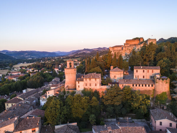
A STROLL AROUND THE CASTLE
This itinerary appears as a proposal of historical and cultural interest to discover the enchanting medieval village of Castrocaro Terme.
The starting point is in front of the entrance to the spa, from here you reach Piazza Mazzini and continue along Via delle Sorgenti and Via della Fratta.
From the beginning of Via Bagnolo, the road begins to climb along the ancient walls and the Fortress. After 1 km, as soon as you pass the aqueduct depot, turn left and descend along a slightly uneven path. After about a hundred metres, on the right you can see the remains of the ancient tower that defended the Porta dell’Olmo, while the imposing maschio (the oldest tower of the fortress) dominates on the left.
Continue for another 100 metres and the asphalt road begins, leading into the historic centre where you can admire the Porta di S. Giovanni, the Bell Tower and, at the end of Via Porta dell’Olmo (on the left-hand side), the Palazzo dei Commissari. Proceeding to the right along Via S. Antonio, we pass the ancient church of S. Nicolò. After passing the door of the same name, on the left of the external facade of the church is the Lapide Dantesca. Continue along Via Garibaldi to return to the entrance to the spa.
Tour: Thermal Bsths – Piazza Mazzini – Via delle Sorgenti – Via della Fratta – Via Bagnolo – Via Porta dell’Olmo – Via S. Antonio – Via Garibaldi.
Starting point: Entrance to the Baths
Route: ring
Journey time: 45 min
Elevation gain: 80 m
Mileage: 1 mile (1,9 km)
Main environment: coast and urbancenter
Road type: asphalted and dirt
Viale Marconi, 37
Castrocaro Terme e Terra del Sole (FC) 47011
Ufficio IAT Castrocaro Terme
Tel: +39 0543 769631

FROM FORLI' TO DOVADOLA TOUR ON FOOT
Exit the Forlì train station and go straight along Viale della Libertà, after about 1 km turn right, following the signs for the centre. Take Corso della Repubblica towards the centre. Cross Piazza Saffi and follow the signs for the Duomo. Credentials can be stamped at the Duomo.
On leaving the Duomo, turn left to exit the city towards the city park. Once on the riverfront, follow a shady gravel road for about 1 km, then turn right and cross the river on the footbridge. Continue along a dirt road between the riverside and cultivated fields, mostly in the shade. The dirt road ends at an asphalt road at Villa Rovere.
At the junction with the road there is a fountain where you can fill your water bottles. Turn left along the road to the church, where you turn left towards Guado Ladino.
We ride along a nice shady dirt road that runs alongside cultivated fields and vineyards to Terra del Sole. You enter Terra del Sole passing under the beautiful arch of the Castello del Capitano della Piazza from the 16th century.
We are 13 km from the start. There is a fountain in the square in front of us. We cross the square until we reach the Castle of the Captain of the Artillery. We leave Terra del Sole and take a cycle path under a tree-lined avenue parallel to the road that leads to Castrocaro (Viale Marconi).
Once in Castrocaro you pass the spa. In the square there are various bars where you can have lunch (we are about halfway along the route, but be careful because there is a good uphill stretch to Montepaolo).
We climb up along a fairly steep dirt track under the sun that leads to an asphalt road: the Sentiero del Santo.
We continue along the asphalt road as far as Villa Bagnolo where there is a fountain. From here you then climb up to Montepaolo where the route joins the Sant’Antonio path.
Mileage: 17 miles (28 km)
Elevation gain: + 554m / – 441m
Journey time: 8 hours including breaks
Viale Marconi, 37
Castrocaro Terme e Terra del Sole (FC) 47011
Ufficio IAT Castrocaro Terme
Tel: +39 0543 769631

A LAND TO TASTE
Castrocaro Terme and Terra del Sole preserve, in addition to the numerous testimonies of their historical events, also a wine and food heritage of ancient tradition, which is still expressed in the production of excellent wines that contribute to enhance the richness of the territory.
There are many producers of typical wines: in Castrocaro, in Via Sadurano, there are the Az. Agr. Fiorentini, the Az. Agr. Sadurano and the Az. Vitivinicola Podere Magnana; in Via Bagnolo there is the Az. Agr. Marta Valpiani and in Via Converselle there is the Podere Mezza Collina. In Terra del Sole there are Agriturismo Monticino, Tenuta Pennita and Az. Agr. Terre Contese. Two different territories united by a single, prestigious wine-making tradition.
Viale Marconi, 37
Castrocaro Terme e Terra del Sole (FC) 47011
Ufficio IAT Castrocaro Terme
Tel: +39 0543 769631

THROUGH THE WINE AND FLAVOURS ROUTE: CASTROCARO AND SURROUNDINGS
The “Wine and Flavours route” tour runs through the Montone Valley and the hills of Castrocaro Terme and Terra del Sole and is promoted by the association of the same name in Forlì-Cesena.
Using the provincial guidebook of the “Strada dei Vini e dei Sapori dei colli di Forlì-Cesena” it is possible, with the help of the map and the various thematic information sheets, to choose a route that involves the main wineries, farm holiday centres, inns and restaurants of Castrocaro Terme and the surrounding area that are part of the initiative and indicated by specific road signs. This is also an opportunity to discover the historical and scenic beauty of the area.
The route runs along the Montone Valley, touching Portico di Romagna, Dovadola, Castrocaro Terme, Terra del Sole and Sadurano.

MUSEUM EDUCATION
The Museum of Man and the Environment of Terra del Sole not only offers a wide range of ways to visit, but also numerous opportunities for museum education.
Through the use of the teaching room and the laboratory it is possible to choose different paths for primary and secondary school pupils. There are numerous teaching modules, including: “The Kitchen, Centre of Domestic Life”, designed to teach children about the multi-functional value of the kitchen; “The Cellar”, to show how the long and laborious process that leads from grapes to wine is organised; “Ancient Crafts”, to learn about the ancient and refined art of the rust-printing on canvas, one of the most particular and characteristic crafts of the area; “The Tombs of the Roman Period”, a workshop dedicated
Piazza d’Armi, 2 47011
Castrocaro Terme e Terra del Sole
Proloco Terra del Sole
Tel: +39 0543 766766

IN THE HEARTH OF THE FORESTE CASENTINESI NATIONAL PARK BY BIKE
The route, starting from Castrocaro, runs through the heart of the National Park, passing through S. Sofia, the Corniolo and the Passo della Braccina. A challenge not to be missed for lovers of climbing, through picturesque villages and breathtaking landscapes.
Viale Marconi, 37
Castrocaro Terme e Terra del Sole (FC) 47011
Ufficio IAT Castrocaro Terme
Tel: +39 0543 769631

MONTE BUSCA EXPERIENCE
This circular route, starting from Castrocaro, takes you to the top of Monte Busca, where a visit to the famous volcano is recommended. You return back from the other valley, climbing Monte Colombo and passing through the town of Predappio.
Viale Marconi, 37
Castrocaro Terme e Terra del Sole (FC) 47011
Ufficio IAT Castrocaro Terme
Tel: +39 0543 769631

MONTE PAOLO BIKE TOUR
Departing from the spa town, this beautiful circular route winds through the picturesque hills of the Romagna Apennines. Of particular interest are the Hermitage of Monte Paolo, the most important Antonian sanctuary in the region, and the picturesque village of Dovadola.
Viale Marconi, 37
Castrocaro Terme e Terra del Sole (FC) 47011
Ufficio IAT Castrocaro Terme
Tel: +39 0543 769631

MONTE PAOLO BIKE TOUR for EXPERTS
A fascinating route immersed in the Apennines that surround the valley. Don’t miss a stop at the Hermitage, the jewel of the area, reached after a series of spectacular hairpin bends.
Viale Marconi, 37
Castrocaro Terme e Terra del Sole (FC) 47011
Ufficio IAT Castrocaro Terme
Tel: +39 0543 769631

RIVER PARK BIKE TOUR
A peaceful route that gently follows the course of the River Montone. Almost entirely practicable on a cycle path, it crosses the Medici citadel of Terra del Sole until it reaches Forlì.
Viale Marconi, 37
Castrocaro Terme e Terra del Sole (FC) 47011
Ufficio IAT Castrocaro Terme
Tel: +39 0543 769631

IN THE CELLAR BETWEEN OIL AND LAVANDER
An immersion in history and nature through three important farms, producers of local excellence. A route that will fully satisfy both the mind and the palate.
Viale Marconi, 37
Castrocaro Terme e Terra del Sole (FC) 47011
Ufficio IAT Castrocaro Terme
Tel: +39 0543 769631

MAGENTA ROUTE
A circular route that takes you from the historic centre of a 16th-century citadel, Terra del Sole, to the spectacular landscapes you will enjoy at the top of the ridge, among valleys and gullies, to the foot of the Rocca di Monte Poggiolo, the first Florentine fortress dating back to 1471.
Viale Marconi, 37
Castrocaro Terme e Terra del Sole (FC) 47011
Ufficio IAT Castrocaro Terme
Tel: +39 0543 769631

CYAN ROUTE
A ring-route starting from the medieval village of Castrocaro and its imposing Fortress, erected on an outcrop of sandstone limestone, the Spungone. From here you will reach the ridge and then descend along the Rio Cozzi path, surrounded by peaks and crags formed by Spungone.
Viale Marconi, 37
Castrocaro Terme e Terra del Sole (FC) 47011
Ufficio IAT Castrocaro Terme
Tel: +39 0543 769631
ORANGE ROUTE
Peaceful panoramic circular route. From the centre of Castrocaro you reach the small village of Pieve Salutare, home of the traditional Grape Festival at the end of September. From here you begin to climb, surrounded by gullies and small wooded areas, suggestive environments that allow you to observe various animal and plant species, before returning to the spa town.
